Watling Street was not the Roman name for the road. It's a Saxon name, that comes from the Waeclingas, people who lived around what is now St Albans, named Waeclingaceste in some sources. Adding 'street', which comes from the Saxon name for the old Roman roads they found crossing the country, this gave the name, in its modern spelling 'Watling Street' for the road in that area. In due course this name cam to estend to the road along its length to Wroxeter, and in the other direction to London, and all the way back to Dover (now largely the A2). The use extended such that Watling Street became almost a generic name for all Roman roads in Britain, and so there are others of this name which have nothing to do with the A5 or even the A2.
A purist in this respect, I'm using the term to apply only to the original line of the Roman road (numbered I by Margary) which later became the A5: and I'm rather pleased to find how much the old name is still in use.
The name Watling Street (or Old Watling Street or, in Milton Keynes, 'V4 Watling Street') still applies to much of the road - more than half of it as far I can establish where it has a name at all. Despite many local names like High Street, or indicating where it goes, like Holyhead Road, the historic name is represented in every county outside London.
It also gives its name to buildings. Along my walk, I have observed and counted 14 residential properties: nine Watling Houses, two each of Watling Lodge and Watling Cottage and one Watling Garth. There are also blocks or estates: Watling Court, Estate and Gardens. The name appears in four farms and six other business premises - including the Watling Street Cafe where I stopped for a tea break, also three sidestreets with the Watling name plus something other than Street, two schools and a Police Station.
Oddest of all is a building in Frogmore with WATLAND PLACE 1898 in it, then added on next door is NEW WATLING PLACE 1899. It looks as if the latter was pointedly correcting the spelling of the neighbour.
There are other 'Roman' namings: a few Roman Roads, Ways and other side street names, a Julius Caesar Way, a Centurion Roundabout and Centurion Park (not in the same place). I patronised the Roman Way Garden Centre (another tea break) and stayed at the rather strange Roman Way Hotel.
The 'street' term, not in its modern usage, but meaning an old Roman road, is part of Theobald Street, Colneystreet and Park Street in Hertfordshire. Markyate appears as 'Markyate or Market Street' in older forms, and Weedon Bec was also named 'Weedon on the Street'. Other forms appear in Stretton Baskerville, Streetway, Stretton and Streetfield.
Friday, 30 June 2017
Saturday, 24 June 2017
The Milestones of Watling Street
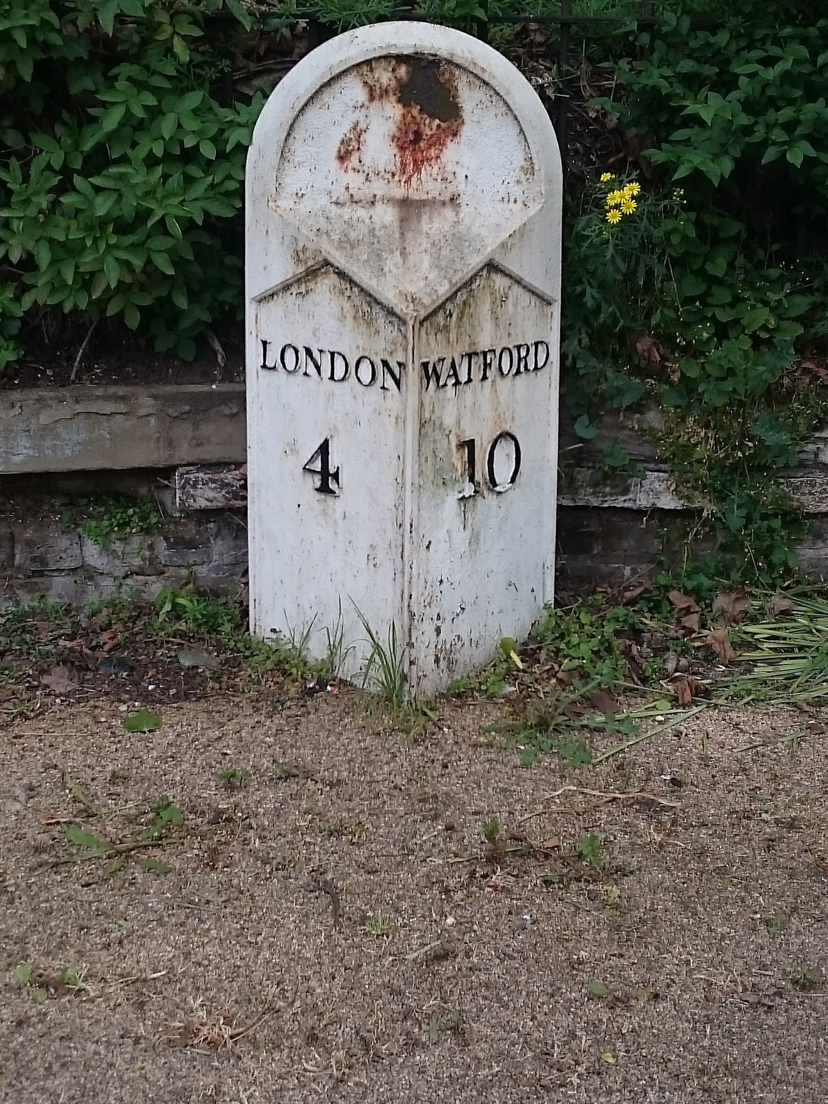
WATFORD 10
The first one, in Cricklewood. It's listed, details here.

LONDON 6
WATFORD 8
Just outside Sainsbury's, West Hendon and nicely renovated and displayed (by them?). Listed here.
The next milestone was one I didn't find, but should have done because it's listed. I walked past the location where it should have been, doubled back and looked even more carefully when retracing my steps. Enquiries since I returned with the Milestone Society and the London Borough of Barnet established it really isn't there. The Milestone Society told me they noticed it was missing in 2005 and reported it to the authorities, but it seems the lost milestone has not been found.

LONDON 18
This one is just inside the driveway of a property on Cobden Hill, south of Radlett. After some thought, I've concluded this isn't a proper milestone in the sense of having been placed here by the authorities for the benefit of highway users, but is a piece of private garden furniture: a nice one.


LONDON 23
ST ALBANS 2
½
Erected by the Dunstable Turnpike Trust, on the road between St Albans and Redbourn. Apparently stolen recently but since recovered and re-erected.

LONDON 27
ST ALBANS 6 ½
MARKATE 1 ½
… 12 FROM …
On 'Old Watling Street', a section of the older road parallel to the A5 between Friars Wash and Markyate.

LONDON 28
On the way into Markyate, this one was difficult to spot being part-buried and, on the day I passed, also half-covered by some tree clippings, which I removed before taking the picture. Listed.

LONDON 48
STONY STRATFORD 3
Cast iron plate on stone.

LONDON 49
STONY STRATFORD 2
Similar to the previous one - but I must have walked past another of these without spotting it.

At Galley Hill roundabout, Stony Stratford. It looks like a milestone but has no legible markings. It is marked as 'Old Milestone' from the earliest Ordnance Survey maps, so has probably been illegible since then.


To London 100 Ms
To Lutterworth 17 ¾ M
To Lichfield 15
Outside the Red Lion Hotel, Atherstone, the listing says this one is 18th century. and it's clearly nicely looked after.

FAZELEY
FAZELEY 2
TAMWORTH 2 ¾
ATHERSTONE 9
LICHFIELD 6
Cast iron, listed.

HINTS
FAZELEY 3
TAMWORTH 3 ¾
ATHERSTONE 10
LICHFIELD 5
An identical design to the Fazeley milepost, and a mile on, but not listed.

WEEFORD
FAZELEY 4
TAMWORTH 4 ¾
ATHERSTONE 11
LICHFIELD 4
Another mile on.

SALOP
...
MILES
The number of miles is now illegible, but its location (close the the A5/A49 junction) and details on older maps suggest that this once showed 19 miles to Salop (Shrewsbury). Listed as late 18th century.

This stone has certain similarities to the previous one, but there's nothing legible on it. Its location suggests that it might once have been the 17 miles to Shrewsbury stone, and seems to have been reused as a gatepost. Or maybe it is just a gatepost.

LONDON 139
SHIFNAL 6
SALOP 11M 6FUR
The listing details say this and the next two belong to the period of Telford's upgrading of the road.

LONDON 140
SHIFNAL 7
SALOP 10M 6FUR

LONDON 141
SHIFNAL 8
SALOP 9M 6FUR
I missed one or two along the way, so don't rely on this as a complete lisitng.
Subscribe to:
Posts (Atom)